404

404

PAGE NOT FOUND

Unfortunately the page you are looking for is not available.

Back to Home

Unique in Fukushima

Goshiki-numa Ponds
Nature & Scenery

Goshiki-numa Ponds

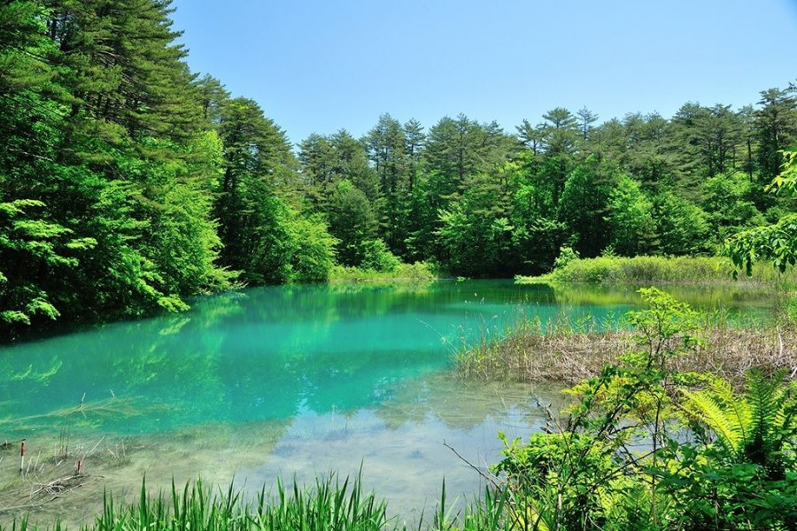
The Goshiki-numa ponds of Urabandai are a cluster of five volcanic lakes at the foot of Mt. Bandai. When Mt. Bandai erupted in 1888, Goshiki-numa - which translates as "Five-Colored Ponds - were formed.In actuality dozens of lakes were created due to the 1888 eruption, but the Goshiki-numa Ponds are the most famous. It was thanks to the eruption that the lakes each took on rich color; the various minerals found in each lake give them a unique color and create a mystical aura.The colors of the Goshiki-numa Ponds also change throughout the year depending on weather and time of day, a truly mysterious phenomenon. The lakes have become a popular tourist destination. The five main lakes are Bishamon, Aka, Ao, Benten, and Midoro, and their colors range from a lime green to deep turquoise to a topaz blue. A scenic walking route guides visitors around the ponds. At 3.6 km in length, this walking route - which will take you past many of the ethereal colors - takes about 70 minutes to complete.If you’d like a view of all five lakes at once, why not take the 4 km walking trail from Bishamon-numa (largest of the five lakes) up to nearby Lake Hibara. Alternatively, if hiking is not on your itinerary, enjoy a simple rowboat out on Bishamon-numa. It’s especially lovely in autumn as the color of the autumn leaves reflects on the deep green surface of the lake. In winter, there are even snowshoe trekking tours offered. The color of the lakes looks particularly vivid in winter, seeing as the minerals in some of the lakes stop them from freezing over, meaning you can see their colors contrasted with the white of the snow.Be sure to stop by the Urabandai Visitor Center, which is a large and well-equipped facility. You can find great information here about tours as well as the various geography, wildlife, and even the history of the area. It’s a great chance to learn more about the ecosystem that makes up the Goshiki-numa Ponds.

Bentenjima
History & Culture

Bentenjima

In a crescent shaped cove separated from the mainland on the small island known as Bentenjima Island, you will find the mysterious Bentenjima Shrine. The vermillion painted tori gate stands out against the jagged stone and the powerful waves. It is believed that the shrine was land based until an earthquake that occurred in 1410 resulted in the formation of this jagged rock island. The construction date of the original shrine is unknown. The island is also known as Wanigafuchi because, according to legend, a creature known as a “wanizame” (crocodile shark) lived on the island. Half crocodile, half shark, this creature can be seen in many old Japanese paintings. The creature may have been believed to cause the swirling water and violent waves that crashed against the rocks, sometimes resulting in people getting swept into the water. Another legend suggests that the wanizame once kidnapped a young woman from Iwaki who had wandered out to explore the island.This coast is lined with small round pebbles that shine when the water hits them. However, do not take any of these pebbles home, legend says that anyone who takes pebbles home from this coast will suffer from eye disease. This area was once a very popular destination for tourists and I highly recommend checking out the photos on the Iwaki city website linked below. It is all in Japanese, but you can read it with the google translate extension on google chrome browsers.

Bandai-Azuma Skyline
Nature & Scenery

Bandai-Azuma Skyline

This sightseeing road that runs from Fukushima City's Takayu Onsen to the Tsuchiyu Pass, commanding panoramic views of the surrounding landscape.The spectacular views that stretch out at an average altitude of 1,350 meters attract visitors time and time again, and Bandai-Azuma Skyline has been selected as one of the 100 Best Roads in Japan.In spring, tourists can enjoy flower viewing while at the same time taking in the otherworldly winter scenery of the "Snow Corridor".In summer, the Nemoto Shakunage (Rhododendron brachycarpum), a species of alpine rose, and other alpine plants display their colorful flowers and fresh, brilliant green leaves. During autumn, the drive warms as roads become enclosed by fiery seasonal leaves.There are also many hot springs in the vicinity of the Skyline where visitors can enjoy a bath and relax stiff muscles while out on a daytrip.The roadway passes next to the crater of Mt. Azuma-Kofuji. Visitors can easily park their car at the nearby guest center and enjoy a short hike up to the crater’s rim.The Bandai-Azuma Skyline Roadway has been selected as one of the top 100 roads in Japan, and unlike many others, this one is free to use. There are rest stops along the way for the hungry traveler; the most popular is Jododaira, as it’s home to a rest house and an observatory.Be sure to plan ahead though, from mid-November to early April the roadway is closed due to heavy winter snowfall.

Top