Paint Your Own Akabeko
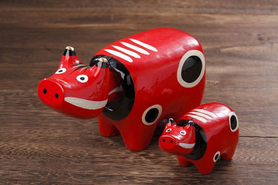
Bookings for the akabeko painting can be made on the official reservation page.What is 'Akabeko'?The akabeko legend started at Enzoji Temple in Yanaizu Town, in the Aizu region. The construction of this temple began in the year 807, but due to a huge earthquake at the end of the seventeenth century, it had to be repaired in 1617. It was during the reconstruction of the temple that the akabeko became a folk legend.It is said that moving the wood and other supplies necessary for the reconstruction work was incredibly difficult because materials had to be transported from various villages upstream of the Tadami River. The materials were heavy and the journey to the temple was long. Cattle were used to transport materials, but many struggled to bear their loads.Then, out of nowhere, appeared a cow with a red coat. (It should be noted that, in the past, the word ‘red’ was used to describe the color ‘brown’, so it is likely that it was a brown cow.) The red cow supported the other cows and helped the priests who were constructing the temple until it was completed. Then, it suddenly vanished.'Akabeko' means 'red cow' in the local dialect.A number of statues of the cow were built inside the temple grounds so that the people of Yanaizu could express their gratitude to the akabeko.In the years following, there was a range of legends about the akabeko, with stories such as families who owned akabeko being rid of sickness upon stroking the cows. They continued to hold their status of bringers of good luck and strength. Families bought or made akabeko toys for their young children to play with.Akabeko Painting ExperiencesIn recent history, the Aizu tradition of painting akabeko began. It is said that this tradition started as something to do for children visiting Aizu-Wakamatsu City as part of school trips. This was when the story of the Akabeko evolved once more, into its newest papier-mâché form. The stripes on the face and back of the papier-mâché Akabeko are said to represent strength and perseverance.There are a number of workshops in Aizu-Wakamatsu City where you can paint your own Akabeko. Most workshops offer the standard red, white, and black paint. These talismans for good health make very cute and lightweight souvenirs to take home for family and friends – or keep for yourself! Those who prefer to buy a ready-painted Akabeko will be able to find it at most souvenir shops.BookingIf you would like to book an akabeko painting experience at the Tsurugajo Kaikan (a shopping complex located next to Tsurugajo Castle), please access this page.