Nanko Park

Nanko Park

In 1801, Matsudaira Sadanobu, the twelfth Lord of Shirakawa, constructed a recreational area which was to be opened to anybody - regardless of status or family background. This recreational area turned into Nanko Park, which is considered to be the Japan's oldest public park. There are Yoshino cherry blossoms (about 800 trees), azaleas, pine trees, and maple trees at the edge of lake. You can enjoy seasonal scenery such as cherry blossoms in spring, fresh green leaves in early summer, autumn colors, and winter scenery with the beautiful contrast of the Nasu Mountains. The park contains Nanko Shrine, where Sadanobu is enshrined as a deity. Next to Nanko Shrine stands the beautiful Japanese gardens Suirakuen. At Suirakuen, visitors can try traditional Japanese tea served in a tea room, which boasts a spectacular view of the gardens. There are a number of shops, cafés, and restaurants along the edge of Lake Nanko. One of the local specialities to look out for is nanko dango, which are sticky rice balls on a skewer, served with different toppings.

Venue Details

Venue Details
Websitehttp://shirakawa315.com/eng/nanko_park.html
Contact

Shirakawa Tourism and Local Products Association

(+81) 248-22-1147

Best SeasonAll Year
ParkingAvailable (See map for location of Lake Nanko East Parking Lot)
Entrance FeeFree
Access Details
AccessNanko, Shirakawa City, Fukushima Pref. 961-0812
View directions
Getting there

By Car: 15 min from Shirakawa I.C. exit on the Tohoku Expressway; 15 min from Shirakawa Chuo Smart exit (ETC only)

By Bus: 10 min from JR Tohoku Shinkansen Shin-shirakawa Station to Nanko Park bus stop

Nearby

The World Glassware Hall
Nature & Scenery

Natsui Senbon-Zakura

There are 1,000 Yoshino cherry blossom trees planted along both sides of the Natsui River, giving the area the name of 'Natsui Senbon-Zakura', which translates as 'Natsui's 1000 cherry trees'. The view of the river stretching out in the distance is calming. The cherry blossoms actually line the river for a distance of 5 km. Natsui Senbon-Zakura offers good spots for taking pictures. Take a walk along the promenade near the banks of the Natsui River for some beautiful shots of the contrast between the glistening river and the cherry blossoms.

The World Glassware Hall
Nature & Scenery

Fujita River Cherry Blossoms

Somei Yoshino cherry blossom trees bloom along both sides of the Fujita River for three kilometers, centering around Horinouchi Bridge near Kikuta Station. The long stretch of leafy foliage features several banks suitable for picnics under the cherry blossoms, which bloom typically in mid-April. (For reference: though blooming periods can change year-to-year, the 2025 blossoms were at full bloom around 15th April.)The riverside is served by nearby Kikuta Station on the Ban-Etsu Line, or there are large car parks near the river walk.

The World Glassware Hall
History & Culture

Nakano Fudoson Temple

Nakano Fudoson is a Zen Buddhist temple built around a waterfall. Nakano Fudoson Temple is dedicated to the Buddhist deity Acala (Fudo in Japanese), one of the Buddhist ‘Kings of Knowledge’. Three forms of this deity can be praised at different areas within this temple.Those hoping to ward off evil & bad luck can worship the deity at the main temple. Those looking to protect their eyesight in the coming year can pray at the Kitoden. Those wanting to worship the Fudo deity even more intimately can do so at the Okunoin cave complex, which contains 36 Buddhist statues.

The World Glassware Hall
History & Culture

Kaiseizan Daijingu Shrine

Kaiseizan Daijingu Shrine (開成山大神宮) is a Shinto shrine located in front of Kaiseizan Park in Koriyama City. The shrine was established in 1876 and is famous for its cherry blossom festival during the spring, as well as for its New Year celebrations, among other festivities.Three deities are enshrined at Kaiseizan Daijingu Shrine: Amaterasu, a Shinto deity believed to be the ancestress of the Imperial family of Japan; Emperor Jimmu, who according to Japanese mythology was the first emperor of Japan; and Toyouke-Ōmikami, the goddess of agriculture and industry in Shintoism.

You might also like

Koriyama Nunobiki Kaze-no-Kogen (Koriyama Nunobiki Wind Farm)
Nature & Scenery

Koriyama Nunobiki Kaze-no-Kogen (Koriyama Nunobiki Wind Farm)

These windy highlands are located at the plateau summit of Mt. Aizu-Nunobiki. It’s location to the south of Lake Inawashiro provides ample breeze to power the 33 windmills that stand majestically atop the highland plateau. Nunobiki Kogen Wind Farm is one of Japan's largest wind farms. It's location at an altitude of about 1,000 meters, makes for a truly fantastic view of the surrounding scenery.From early August to early September, visitors can enjoy amazing vistas of the beautiful himawari batake (sunflower fields). The sunflowers here are planted at 3 different intervals, meaning that visitors can enjoy seeing them throughout the summer months.Sunflowers aren’t all that Koriyama Nunobiki Kaze-no-Kogen has to offer flower lovers:  - from August to September - you can see cosmos blooming. Of course, visitors are always greeted with superb views of Lake Inawashiro and Mt. Bandai.There are walking courses along the plateau, so visitors can explore the area and snap some great photos. One really amazing photo spot can be found at the observatory. Depending on the timing of your visit, you might be able to purchase some local vegetables at temporary stalls. We recommend trying the region’s famous Nunobiki Plateau daikon radish.   

Mt. Issaikyo
Nature & Scenery

Mt. Issaikyo

One of the mountains climbable from the Jododaira Plateau, Mt. Issaikyo is a robust several-hour hike suitable for intermediate-level hikers.In addition to spectacular views of the surrounding area, the mountain is also one of the main pathways to, and viewpoints for, the ‘Witch’s Eye’ lake at Goshikinuma, which stretches out in a valley visible from the Issaikyo summit. (The lake is reachable from the summit, although the terrain is relatively steep.)Visitors to the area typically park at the Jododaira Visitor Center, from which they have a choice of options: Kamanuma lake due west, Okenuma Pond to the south, and the Azuma-Kofuji crater with its panoramic views over Fukushima City to the east.To the north, however, stands Mt. Issaikyo. With a summit of 1,949m and rugged terrain on the climb, it may not be suitable for absolute beginner hikers, but nor is it a whole-day slog like climbing Mt. Fuji. Views from the top of the mountain are spectacular and well worth the climb – a blanket of immaculate white clouds spreads out in all directions. Likewise, the ascent gives great views of the Azuma-Kofuji crater with its iconic inverted shape.The Jododaira Plateau is typically best accessed by car, a journey which takes travellers from Fukushima City up the Bandai-Azuma Skyline sightseeing road and offers fantastic views, especially in autumn.Please be aware that the Mt. Issaikyo trail, and the Jododaira Plateau in general, is closed to visitors during winter due to heavy snowfall.

Bandai-Azuma Skyline
Nature & Scenery

Bandai-Azuma Skyline

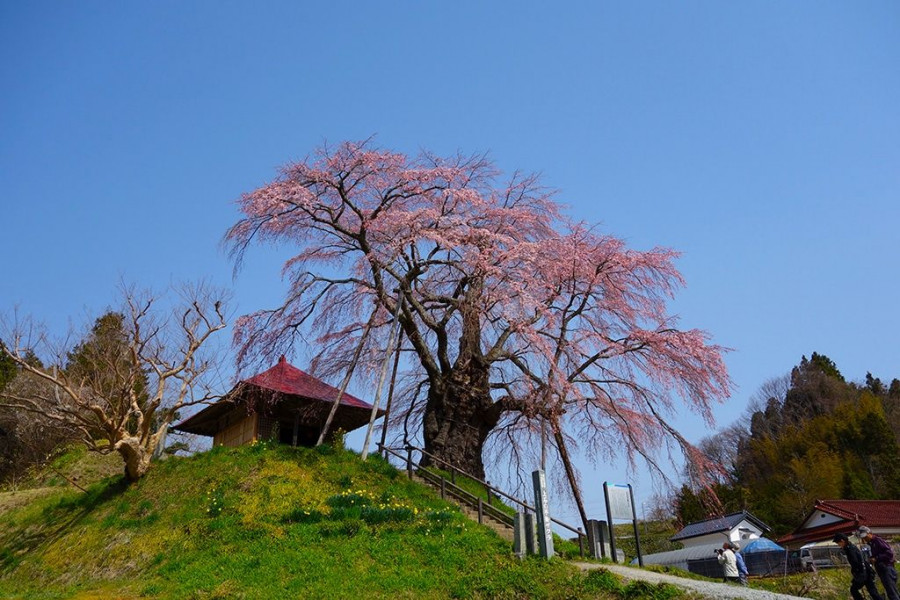
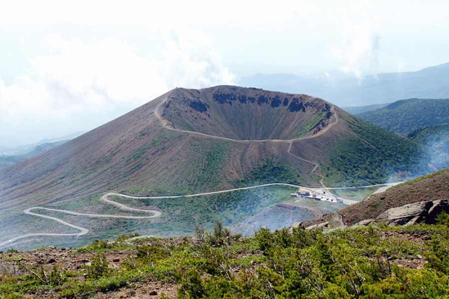
There is a special bus running from Fukushima Station to the Jododaira plateau while the mountain is open. Please visit the Jododaira Sky Access page for more details.Jododaira and the Bandai-Azuma Skyline mountain road are open from April 21, 2026.This sightseeing road that runs from Fukushima City's Takayu Onsen to the Tsuchiyu Pass, commanding panoramic views of the surrounding landscape.The spectacular views that stretch out at an average altitude of 1,350 meters attract visitors time and time again, and Bandai-Azuma Skyline has been selected as one of the 100 Best Roads in Japan.In spring, tourists can enjoy flower viewing while at the same time taking in the otherworldly winter scenery of the "Snow Corridor".In summer, the Nemoto Shakunage (Rhododendron brachycarpum), a species of alpine rose, and other alpine plants display their colorful flowers and fresh, brilliant green leaves. During autumn, the drive warms as roads become enclosed by fiery seasonal leaves.There are also many hot springs in the vicinity of the Skyline where visitors can enjoy a bath and relax stiff muscles while out on a daytrip.The roadway passes next to the crater of Mt. Azuma-Kofuji. Visitors can easily park their car at the nearby guest center and enjoy a short hike up to the crater’s rim.The Bandai-Azuma Skyline Roadway has been selected as one of the top 100 roads in Japan, and unlike many others, this one is free to use. There are rest stops along the way for the hungry traveler; the most popular is Jododaira, as it’s home to a rest house and an observatory.Be sure to plan ahead though, from mid-November to early April the roadway is closed due to heavy winter snowfall.

Bandai-Azuma Skyline Snow Corridor
Nature & Scenery

Bandai-Azuma Skyline Snow Corridor

The Bandai-Azuma Skyline is a 29-kilometer sightseeing road to the west of Fukushima City. The roadway makes for a lovely drive as it weaves its way through the Azuma Mountain Range, tying together Takayu Onsen and the Tsuchiyu Mountain Pass. It has even been nicknamed “the road that runs across the sky” as it offers such spectacular panoramic views of Fukushima City and the beautiful countryside. The road opens for the season in early April, coinciding with cherry blossom viewing season in Fukushima City. At Fukushima City's Hanamiyama, you can see the rare combination of cherry blossoms and snow in the course of a single day.

Top