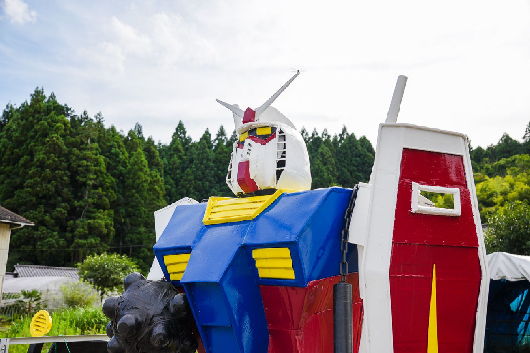
Bandai-Azuma Skyline Snow Corridor

Bandai-Azuma Skyline Snow Corridor

The Bandai-Azuma Skyline is a 29-kilometer sightseeing road to the west of Fukushima City. The roadway makes for a lovely drive as it weaves its way through the Azuma Mountain Range, tying together Takayu Onsen and the Tsuchiyu Mountain Pass. It has even been nicknamed “the road that runs across the sky” as it offers such spectacular panoramic views of Fukushima City and the beautiful countryside.

The road opens for the season in early April, coinciding with cherry blossom viewing season in Fukushima City. At Fukushima City's Hanamiyama, you can see the rare combination of cherry blossoms and snow in the course of a single day.

Venue Details

Venue Details
Websitehttps://fukushima-guide.jp/discover/bandai-azuma-skyline/
Contact

Fukushima City Tourism & Convention Association

(+81) 24-563-5554

fukushima.guide@f-kankou.jp

Best Season
  • Spring
ParkingParking is available at Jododaira Rest House.
Related infoThe road is closed during the winter season, from mid-November until mid-April. Best season: The first ten days of April, immediately following the annual reopening of the Bandai-Azuma Skyline. The snow thaws steadily, so it is best to come early.
Access Details
AccessTorikodaira, Chinai, Tsuchiyu Onsen-Machi, Fukushima City, Fukushima Pref.
View directions
Getting there

By Car to the Skyline Takayu Gate: From Fukushima Nishi I.C. exit off the Tohoku Expressway, take Route 115 toward Takayu Onsen for about 25 min. It takes around 30 min to reach the Snow Corridor after passing through the Takayu Gate.

Nearby

The World Glassware Hall
Nature & Scenery

Koshidai no Sakura (The Koshidai Cherry Tree)

This huge Japanese cherry tree is over 400 years old and has been designated as a national Natural Treasure. The tree has a trunk circumference of about 7.2 meters and stands 20 meters high, and was thus selected as one of the "100 Giants of the Forest" by Japan's Forestry Agency. Koshidai Cherry Blossom Festival is held every year on May 3. A Yabusame horseback archery event accompanied by taiko drumming takes place during this festival, and local organizations set up food stalls.Photo tip: Try taking photos from the south side of cherry blossoms.

The World Glassware Hall
Nature & Scenery

Majyo-no-hitomi (The Witches’ Eye Lake)

Majyo-no-hitomi, or The Witches’ Eye Lake, is a volcanic lake that was formed during a volcanic eruption many years ago. Unique minerals in the water cause the lake to appear different colors, giving the lake it’s official name of Goshiki-numa (Five Colored Lake), but most often it is a bright blue.  The nickname of “Witches Eye” comes from the unique appearance of the lake that is visible in late spring when the snow melts enough so that only a white ring remains around the lake to form the white of what appears to be an enormous single eye. This lake viewpoint can be reached by an intermediate hike that begins at the Jododaira Visitors Center, stop by for a map and safety information before hiking. 

The World Glassware Hall
Nature & Scenery

Bandai-Azuma Lake Line

Bandai-Azuma Lake Line is a sightseeing road that runs for 13.1 km, connecting Inawashiro Town and Kitashiobara Village. Outstanding backdrops of hundreds of lakes, including Lake Akimoto, Lake Onogawa, and Lake Hibara can be seen from along the road. The Nakatsugawa Valley, which lies half-way along the route, offers a wonderful view of a combination of rock surfaces polished by strong water currents and woodland greenery. A rest-house area with washrooms stands near the valley and visitors can enjoy trekking along the walking trails from the season of fresh green leaves through to the end of the season of red and yellow foliage. The valley is particularly famous as one of the most scenic foliage-viewing spots in Japan with many photographers visiting from both inside and outside of the prefecture. Enjoy a beautiful drive through this landscape when the new leaves of spring are fresh and green or when the autumn beauty of the valley glistens with red and yellow foliage of beeches, buckeyes, and maples.

You might also like

Mt. Shinobu (Shinobuyama)
Nature & Scenery

Mt. Shinobu (Shinobuyama)

Mt. Shinobu, with a total altitude of 275 meters, is one of the landmarks of Fukushima City. It is estimated that it formed about 500.000 years ago when the Fukushima basin caved in and Mt. Shinobu became an isolated hill, which later became the object of multiple local poems, stories, and legends.Visitors can hike up Mt. Shinobu for unobstructed views of the cityscapes. Hikers of all levels can try climbing Mt. Shinobu, as its peak can be reached in a few hours and many parts of it can be reached by car.Each year in April there is a spring festival with cherry blossom night illuminations that attract hordes of visitors. Summer and autumn are also great times to follow the hiking routes at Mt. Shinobu.A spiritual power spot for locals, Haguro Shrine can be found at the top of the central peak, where there is also a giant straw sandal that weighs about 2 tons and is 12 meters in length and is believed to be among the biggest in Japan. The sandal is paraded along Fukushima City each year in August during the Waraji Festival. Also in Mt. Shinobu, you can find the Shinobuyama Neko Inari Jinja(‘cat shrine’), and the Gokoku Shrine, along with several parks.For stunning views of the city, including the Shinkansen bullet train tracks, head to the Karasugasaki Observation Deck on the western side. Located nearby are the Fukushima Prefectural Museum of Art and the Fukushima Prefectural Library. @Redicoverfukushima

Top