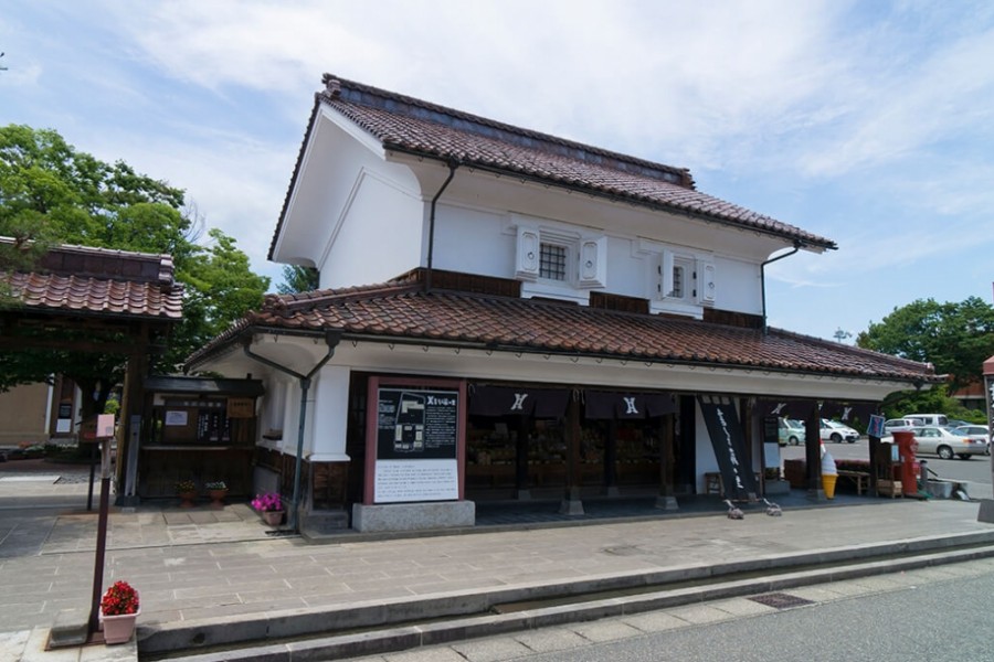
Lake Akimoto

Lake Akimoto

When Mt. Bandai erupted in the Urabandai area in 1888, Okuragawa River and Nakatsugawa River were blocked, resulting in the creation of Lake Akimoto. This is the deepest lake among the three Urabandai lakes (Lake Hibara, Lake Onogawa, Lake Akimoto) and the second biggest lake after Lake Hibara. Boats, fishing and camping are available.

Venue Details

Venue Details
Websitehttps://www.urabandai-inf.com/en/?page_id=24972
Contact

Urabandai Tourism Association

(+81) 241-32-2349

Best SeasonAll Year
ParkingNone
Access Details
AccessAkimoto, Kitashiobara Village, Yama District, Fukushima Pref.
View directions
Getting there

By Car: 25 min drive from the Inawashiro Bandaikogen I.C. exit off the Ban-etsu Expressway

Nearby

The World Glassware Hall
Gourmet & Shopping

Suehiro Sake Brewery Kaeigura

Suehiro Sake Brewery was founded at the end of the Edo Period, in the mid 19th century. The Kaeigura (the building where the sake is brewed) has been designated as an important historical building by Aizu-Wakamatsu City. Here, visitors can take a guided tour of the sake-brewing process, as well as of old Japanese-style rooms which were built during the Meiji Period. The brewing process takes place from October to March every year. During this time, visitors can see the process and conditions inside the fermentation tanks. Visitors may try between six and ten different kinds of sake for free year-round. Suehiro sake and other Aizu products are available for sale on-site. On the left side after entering the gate stands a café called Kissa Ann. The architecture of Kissa Ann was remodelled from the Kaeigura's oldest storehouse. Here, you can enjoy coffee made with water prepared especially for making sake, and cake made using high-quality sake.

The World Glassware Hall
History & Culture

The Grave of the Matsudaira Family

The gravesite was constructed in 1657 when Masayori, the heir of the first Aizu lord Hoshina Masayuki, passed away. Tombs for the second lord Masatsune through the ninth lord Takamori, as well as their wives and children, stand side by side. A Buddhist funeral was conducted for the second lord, but the Shinto style was used for all the other lords. This gravesite is one of Japan’s top daimyo family graves, and is known for its history and scale. The Grave of the Matsudaira Family has also been nationally recognized as an Important Historic Site.

The World Glassware Hall
Nature & Scenery

Mt. Bandai

Originally known as Iwahashi-yama, literally a rock ladder to the sky, the renamed Mt. Bandai is no less impressive. Often referred to as 'Aizu's Mt. Fuji', Mt. Bandai is one of the 100 most famous mountains in Japan, and has even been selected as one of the top 100 geographic landmarks in Japan. In 2011, the mountain was certified as a geopark, which is a unified area with geological heritage and international significance, as defined by UNESCO. There are seven climbing routes for Mt. Bandai, with the trail starting at the Happodai trailhead being the most popular, and easiest route. From the Happodai trailhead, the 3.5 km route takes around 2 hours to reach the summit.The various routes range from 2 to 4 hours and from 3 to 7 km. At Koubou Shimizu, one of the mountain stops, there are two shops where trekkers can buy drinks, snacks, and souvenirs, but please note that there is no accommodation available. For many Buddhist mountain fanatics, Mt. Bandai holds a place of great significance. Enichi-ji Temple, located on the southwestern foot of Mt. Bandai, is a popular temple to visit nearby. The mountains situated around the temple make for a serene vista where one can feel the power of nature. Enichi-ji Temple was founded one year after Mt. Bandai erupted, in 807 C.E.; in the past, some superstitious people believed there was a connection between the eruption and the temple’s founding... Interestingly, Mt. Bandai used to be shaped more like the famous Mt. Fuji, but after a volcanic eruption in 1888, the shape changed to what we see today. It is thanks to that eruption that the mountain gained its rugged, sharp look and the Urabandai area behind Mt. Bandai was created. For non-hikers, the Bandaisan Gold Line is a popular sightseeing road that leads up the southwestern side and offers brilliant vistas of the foliage, especially in autumn when the colors change.

The World Glassware Hall
Nature & Scenery

To-no-hetsuri Crags

A national natural monument, To-no-hetsuri Crags consists of tower-shaped cliffs overlooking Okawa River. Hetsuri is an Aizu word meaning "a cliff overlooking a river" or "a steep slope" in the local dialect.These strange-shaped cliffs are thought to be made of various types of rocks formed around 28 million years ago and feature deep cracks along the vertical joints. Thanks to trees growing between the white multi-layered rocks the view in autumn is quite spectacular. In spring and summer, the lush greens create a beautiful carpet down the rocks; in winter, the heavy snows make To-no-hetsuri Crags look otherworldly.The 200-meter long, natural cliff formation has alternating types of rocks that also include a relatively soft strata, which have been eroded by rain and wind, resulting in distinctive and eye-catching dips and curves in the rock face that resemble a forest of towers. Each of these tower-like rocks has its own name: Eagle Tower, Hawk Tower, Lion Tower, House Tower, Turret Tower, Nine-Ring Tower, Elephant Tower, Goma (fire ritual) Tower, Eboshi (tall hat worn by male aristocrats in the Heian Period) Rock, Folding Screen Rock, Stage Rock, and Sumo Arena Rock.Visitors to the area of To-no-hetsuri Crags can best enjoy the dynamic scenery by crossing the nearby suspension bridge. The suspension bridge offers a breathtaking sight of the river and cliff sides. At the foot of the cliff there is also a small shrine dedicated to the Bodhisattva of Wisdom. Another great way to enjoy To-no-hetsuri Crags is from the observatory neighboring the area where guests can view a panoramic scene of Okawa River, To-no-hetsuri Crags, and the suspension bridge. After enjoying the beautiful sight, head over to the local shopping area for restaurants and souvenirs.

You might also like

Kannonji-gawa River Cherry Trees
Nature & Scenery

Kannonji-gawa River Cherry Trees

Only a one-minute walk north of Kawageta Station (JR Ban-etsu West Line) is this beautiful 1 km-path along the banks of the Kannonji-gawa River. In the spring the path transforms into a spectacular tunnel of Yoshino cherry trees and weeping cherry trees. Kannonji-gawa River is perhaps the most fantastic place to see cherry blossoms in Fukushima Prefecture; the calming river and the lovely petals falling like snow are a sight that can’t be beat. The lush green bank contrasting with the pale pink blossoms creates an unforgettable scene.Altogether there are about 200 trees growing along the Kannonji-gawa River on both banks. Additionally, the river maintains its natural curves and bends as it hasn’t undergone any work to adapt its shape to the city surrounding it. It’s one of Fukushima’s most splendid and respected natural landscapes. Currently, the Kannonji-gawa River cherry trees rank number 11 of the best places to see cherry blossoms in the entire Tohoku region!While enjoying the delicate blossoms and the sweet, fresh air, visitors to Kannonji-gawa River can also enjoy some of the tasty food from street vendors available only during the cherry blossom season. We’d really recommend a springtime picnic right on the river bank with various yatai (food stand) delicacies. Be sure to come back during the evening when the trees are illuminated, and the river transforms into a magical dreamscape.

Nakatsugawa Valley
Nature & Scenery

Nakatsugawa Valley

Nakatsugawa Valley is famous for its beautiful fall foliage. The Nakatsugawa River is a clear stream flowing down from Bandai Kogen (Bandai Highland) to Lake Akimoto. In autumn, the leaves of the many trees, such as maples, alders, and wild cherry trees, turn brilliant and bold colors. The valley can be reached via the lakeside cycling road or by following the trail from the Nakatsugawa Valley Rest House Lake Line Parking Area. Take a relaxing stroll along the ravine while breathing in the mountain air full of healthy negative ions.Many people park on the road closest to the bridge, but for most people it's easier to park at the Rest House and walk the short trail (less than 5 minutes) down to the bridge. There is also a shop and a canteen-style restaurant at the Rest House.

Top