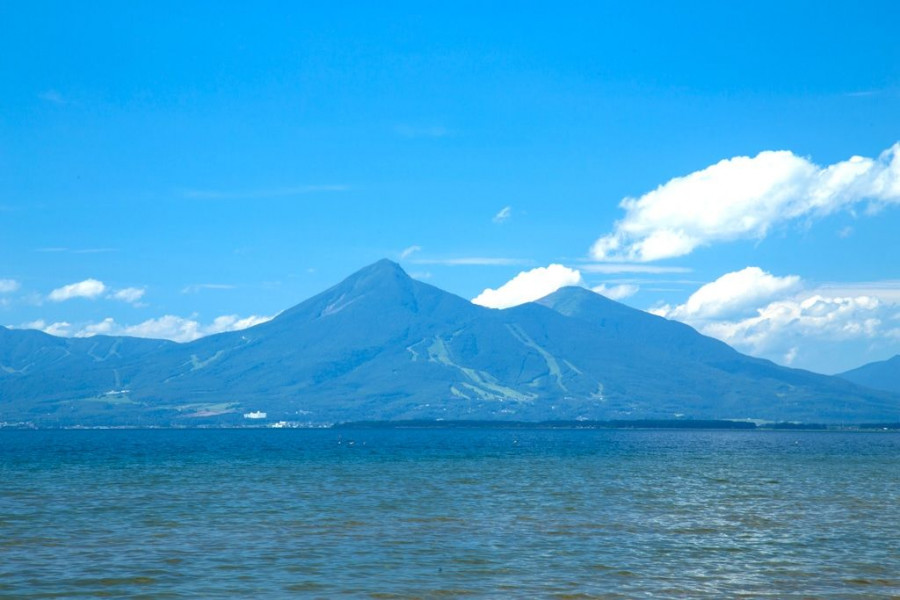
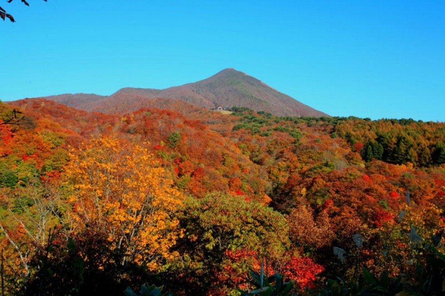
Kannon-numa Forest Park

Kannon-numa Forest Park

Kannon-numa Forest Park (観音沼森林公園) is a picturesque natural area in the Minamiaizu District of Southern Fukushima Prefecture.

A wide variety of vegetation, flowers, and birds can be found at Kannon-numa Forest Park. There are nine walking trails, each offering unique sights. The main trail covers about 1.2 km and goes around the Kannon-numa swamp, which is one of the main highlights of the park. 

The park becomes transformed in each season, with cherry blossoms in spring and hydrangeas in the summer, and it is particularly popular with visitors during the autumn. The colorful trees reflected on the swamp’s waters make for a lovely sight, making it one of the main autumn attractions in the area. The best time to visit to see the autumn foliage is typically from late October to early November. There is also a shrine, Dake Kannondo, believed to have been built over 1,000 years ago.

Located about 35 minutes from Ouchi-juku by car, this park is the perfect place to bask in the natural wonders of Shimogo Town. 

Venue Details

Venue Details
Websitehttps://www.town.shimogo.fukushima.jp/organization/sougouseisaku/1/2/Kannon_numa_Forest_Park_en.html
Contact

Shimogo Town Tourism Association
0241-69-1144

Best SeasonAll Year
ParkingAvailable
Access Details
AccessNogiwashinden, Shimogo Town, Minamiaizu District, Fukushima Pref. 969-5341
View directions
Getting there

By car: Approx. 20 minutes by car from the Aizu-Tajima Station (Aizu Tetsudo Line)

Useful Links

Ouchi-juku

To-No-Hetsuri Crags


Nearby

The World Glassware Hall
History & Culture

Maezawa L-shaped Farmhouses

The deep snows of the Aizu region meant that, in the past, cut off from other areas for months at a time, its residents had to use all their wits just to make it through the winters. These L-shaped farmhouses known as "magariya" conceal a number of the innovations developed by this local people.As you can see in the layout of the house, the long earth floor stretches out towards the road. Long ago, horses were indispensable in farming, but the deep snow of winter meant that keeping them tied up in external stables was cruel. Therefore, stables were built into the house, meaning that the unfloored working area inevitably became larger. Having this area far from the road made getting to the road through the snow more difficult, as up to a meter can fall overnight. Accordingly, with the aim of reducing work, locating this working area as close as feasible to the road ended up with the house being laid out in an L-shape.Many of these houses were built in Maezawa and throughout Tateiwa Village, as a way of living with horses in the deep snows of the Aizu region.The houses have become more and more comfortable over time, with the "magariya" design lasting until the present day. While this magariya-style farmhouse used to be built everywhere that saw heavy snow, they are gradually disappearing. Accordingly, the Maezawa magariya have been designated as historical cultural assets.In 1985, the village began actively preserving these houses, and this area now attracts many visitors. One of the magariya buildings have been repurposed into a museum in the village where visitors can learn about life in Maezawa.

The World Glassware Hall
Nature & Scenery

Mt. Bandai

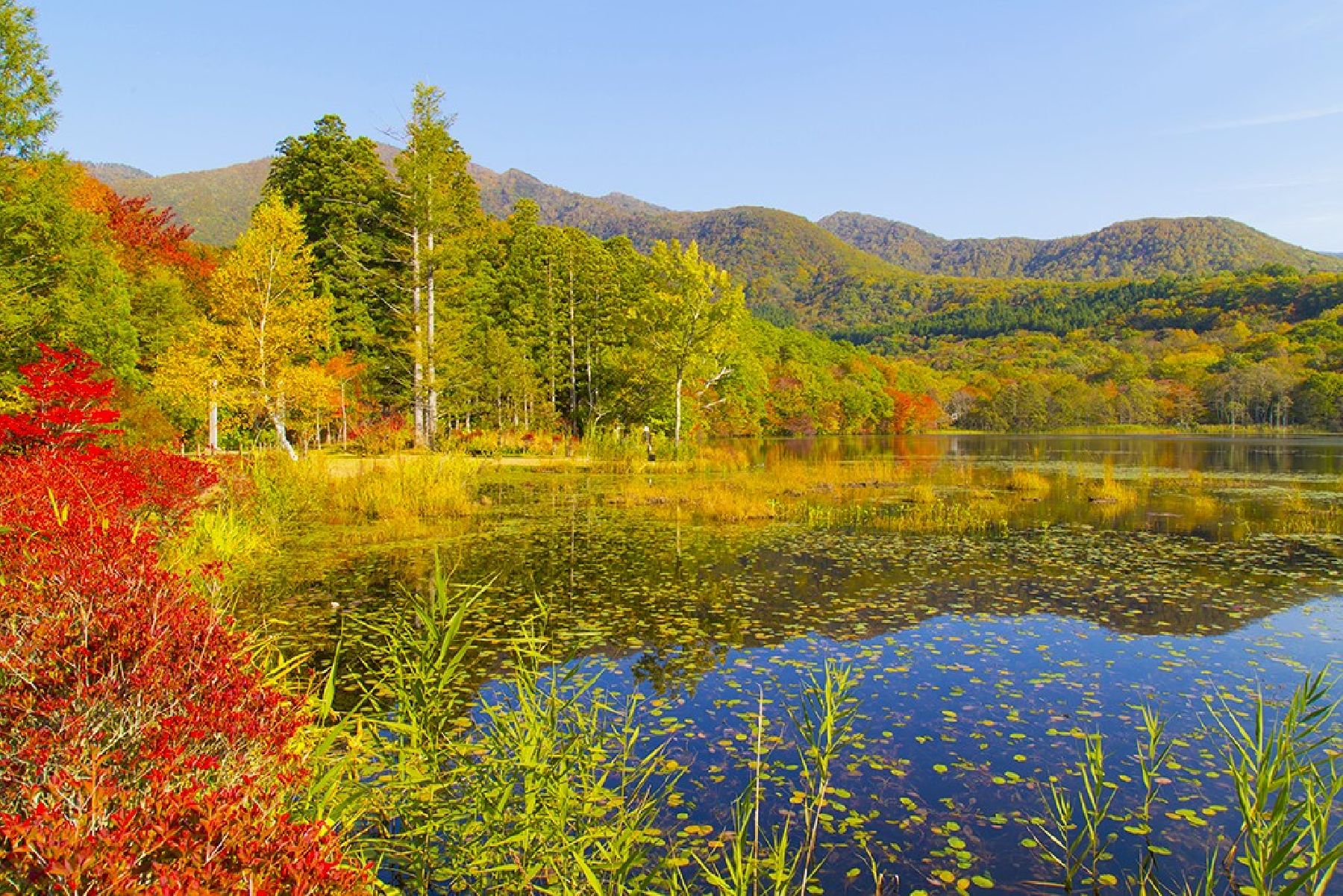
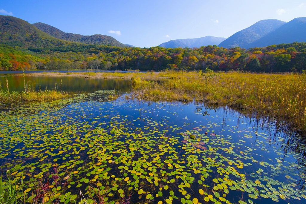
Originally known as Iwahashi-yama, literally a rock ladder to the sky, the renamed Mt. Bandai is no less impressive. Often referred to as 'Aizu's Mt. Fuji', Mt. Bandai is one of the 100 most famous mountains in Japan, and has even been selected as one of the top 100 geographic landmarks in Japan. In 2011, the mountain was certified as a geopark, which is a unified area with geological heritage and international significance, as defined by UNESCO. There are seven climbing routes for Mt. Bandai, with the trail starting at the Happodai trailhead being the most popular, and easiest route. From the Happodai trailhead, the 3.5 km route takes around 2 hours to reach the summit.The various routes range from 2 to 4 hours and from 3 to 7 km. At Koubou Shimizu, one of the mountain stops, there are two shops where trekkers can buy drinks, snacks, and souvenirs, but please note that there is no accommodation available. For many Buddhist mountain fanatics, Mt. Bandai holds a place of great significance. Enichi-ji Temple, located on the southwestern foot of Mt. Bandai, is a popular temple to visit nearby. The mountains situated around the temple make for a serene vista where one can feel the power of nature. Enichi-ji Temple was founded one year after Mt. Bandai erupted, in 807 C.E.; in the past, some superstitious people believed there was a connection between the eruption and the temple’s founding... Interestingly, Mt. Bandai used to be shaped more like the famous Mt. Fuji, but after a volcanic eruption in 1888, the shape changed to what we see today. It is thanks to that eruption that the mountain gained its rugged, sharp look and the Urabandai area behind Mt. Bandai was created. For non-hikers, the Bandaisan Gold Line is a popular sightseeing road that leads up the southwestern side and offers brilliant vistas of the foliage, especially in autumn when the colors change.

You might also like

Lake Inawashiro
Nature & Scenery

Lake Inawashiro

Japan's fourth-largest freshwater lake, Lake Inawashiro is situated in Bandai Asahi National Park. It is also known as the “Heavenly Mirror Lake” and has a surface area of 104 square kilometers! The combination of Lake Inawashiro and Mt. Bandai form one of Aizu's representative landscapes. And being less than three hours from Tokyo by shinkansen and local train means that you have easy access from a major transport hub.The lake offers year-round fun. Enjoy cherry blossoms in spring at Iwahashi Shrine, one of Aizu’s five famous cherry trees. Summer at Lake Inawashiro is slightly cooler than the rest of Fukushima, so take advantage of camping by the lakeshore, and a wide variety of marine sports. Colored leaves and hikes are the popular thing to do in autumn, view the fiery hues and take in the crisp air. In winter, visitors can enjoy fresh powder snow and winter thrills in the form of skiing and snowboarding; and you can even catch a glimpse of migrating swans on the shores.It’s truly a beauty no matter when you decide to visit. There are also a wide range of scenic spots from where visitors can take photographs and soak in the view. It’s a great place to escape from the stress of work and life or just to experience Japanese nature and landscapes.Lake Inawashiro's size means that it is accessible from a number of sightseeing spots, including Tenkyokaku stately house and Hideo Noguchi Memorial Museum (a museum dedicated to the life and work of a Japanese scientist famous for his research on yellow fever). There’s plenty more to do nearby: view some amazing works by international artists at the Morohashi Museum of Modern Art, or visit the rainbow-colored Goshiki-numa Ponds.

Goshiki-numa Ponds
Nature & Scenery

Goshiki-numa Ponds

The Goshiki-numa ponds of Urabandai are a cluster of five volcanic lakes at the foot of Mt. Bandai. When Mt. Bandai erupted in 1888, Goshiki-numa - which translates as "Five-Colored Ponds - were formed.In actuality dozens of lakes were created due to the 1888 eruption, but the Goshiki-numa Ponds are the most famous. It was thanks to the eruption that the lakes each took on rich color; the various minerals found in each lake give them a unique color and create a mystical aura.The colors of the Goshiki-numa Ponds also change throughout the year depending on weather and time of day, a truly mysterious phenomenon. The lakes have become a popular tourist destination. The five main lakes are Bishamon, Aka, Ao, Benten, and Midoro, and their colors range from a lime green to deep turquoise to a topaz blue. A scenic walking route guides visitors around the ponds. At 3.6 km in length, this walking route - which will take you past many of the ethereal colors - takes about 70 minutes to complete.If you’d like a view of all five lakes at once, why not take the 4 km walking trail from Bishamon-numa (largest of the five lakes) up to nearby Lake Hibara. Alternatively, if hiking is not on your itinerary, enjoy a simple rowboat out on Bishamon-numa. It’s especially lovely in autumn as the color of the autumn leaves reflects on the deep green surface of the lake. In winter, there are even snowshoe trekking tours offered. The color of the lakes looks particularly vivid in winter, seeing as the minerals in some of the lakes stop them from freezing over, meaning you can see their colors contrasted with the white of the snow.Be sure to stop by the Urabandai Visitor Center, which is a large and well-equipped facility. You can find great information here about tours as well as the various geography, wildlife, and even the history of the area. It’s a great chance to learn more about the ecosystem that makes up the Goshiki-numa Ponds.

Byobuiwa Crags
Nature & Scenery

Byobuiwa Crags

The Byobuiwa Crags (屏風岩) are a rock formation in Minamiaizu, in the Southern area of Fukushima Prefecture. The rocks have eroded through many years to their current shape. The crags are light in color, offering an interesting contrast with the blue of the gushing Ina river, and the vibrant colors of the surrounding foliage, creating a scenery that becomes particularly poignant during the autumn. Visitors can stroll the walking course around the crags, which takes approximately 20 minutes to be completed and includes several interesting picture spots.

Top