Hot Springs
Noji Onsen
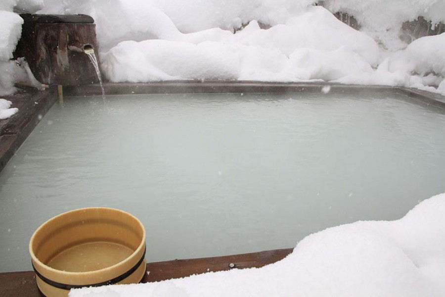
Noji Onsen is a beautifully scenic onsen resort in Adatara mountains. It is especially breathtaking when the outdoor baths, and their cloudy white waters, are surrounded by stunning snowy landscapes in winter.
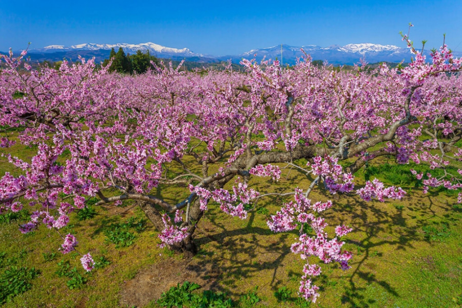
Koori Town, home to some 236 acres of peach orchards, is a wonderful place to view peach blossoms when spring rolls around.
24,000 trees fill the 120 hectares of peach orchards located along the banks of the Abukuma in Koori Town's Danzaki area - many of these are located along a road known locally as 'the Peach Line'.
When these flowers all open their petals in unison, the landscape is transformed into a sea of pink, truly a utopian vista. Their Majesties the Emperor and Empress (the Crown Prince and Princess at the time) walked through this orchard on April 26 1996 - an event which is commemorated with a memorial tablet that stands along the Peach Line.
Visitors to the peach orchards on the banks of the Abukuma river will be treated to views of Mt. Handa, the symbol of Koori Town.
The best time to visit the peach orchards is mid-April.
| Website | https://www.town.koori.fukushima.jp/kankou/index.html(Japanese) |
|---|---|
| Contact | Koori Town Industrial Development Section (+81) 24-582-2126 sangyoshinko@town.koori.fukushima.jp |
| Best Season |
|
| Access | Along the Abukuma River, Koori Town, Fukushima Pref. View directions |
|---|---|
| Getting there | By Car: 10 min from Kunimi I.C. exit off the Tohoku Expressway By Train: 40 min walk from Koori Station on the JR Tohoku Main Line |
Noji Onsen is a beautifully scenic onsen resort in Adatara mountains. It is especially breathtaking when the outdoor baths, and their cloudy white waters, are surrounded by stunning snowy landscapes in winter.
Fukushima City's Iizaka Onsen has been used as an onsen town for over 1,000 years, and has been visited by legendary figures in Japanese literature such as Matsuo Basho (1644-1694), the master of haiku poems. Locals in Iizaka Onsen pride themselves on the well-known Japanese phrase “Beppu in the West; Iizaka in the East”, which refers to the best onsen towns in Japan.The Surikami River that passes through the town is lined on either side by 9 high-rise ryokan (Japanese-style inns). More ryokan can be found scattered about Iizaka Onsen. The town is also dotted with a number of communal baths and public foot baths. Some of Iizaka Onsen’s most well-loved local foods include include Enban Gyoza and soft-boiled eggs known as Onsen Tamago. Iizaka Onsen is also close to sightseeing spots such as Hanamomo no Sato, the Fruit Line, and Nakano Fudoson Temple.Iizaka Onsen is the site of the Iizaka Fighting Festival in October, the one night a year where a lively fight atmosphere overtakes the usually sleepy hot spring resort.
Hanamiyama Park is a privately-owned field for flowering and ornamental trees, in southeast Fukushima City.The park is located within a satoyama-type landscape i.e. managed woodland hill country close to human habitat. What originally began more than 60 years ago with local farmers planting flowers and trees, has grown into a beautiful scene. The landowner generously turned the area into a park in 1959 to allow visitors to enjoy the beautiful flowers there.Hanamiyama Park, and the wider Hanamiyama area, is now visited by thousands of admirers every year!Springtime visits see cherry, plum, and forsythia trees paint everything in vivid colors. A gentle pink and purple landscape waving in the breeze with the picturesque snow-capped Azuma Mountains in the distance makes for an amazing sight.The riot of spring colors is spectacular enough to merit calling this park Fukushima's very own paradise.The flowering landscape moves all who see it and has been preserved through the cooperation of the local residents. Enjoy a leisurely one-hour stroll that will take you from the foot of the hill to the summit. Travel through groves of flowering trees and other vibrant flowers in full bloom.Hanamiyama is the perfect getaway for a day for nature lovers, hikers, or people trying to escape for a short time.The best part is that spring isn’t the only beautiful time to visit. Marvel in wonder during the lush green summer foliage or the dappled colors of autumn. When you visit this fairytale-like wonderland, it is recommended that visitors wear comfortable walking shoes as the terrain includes graveled paths, steep slopes, and slippery areas. Mid- through late April is the peak season, so ready your camera and your heart for the beauty that awaits.
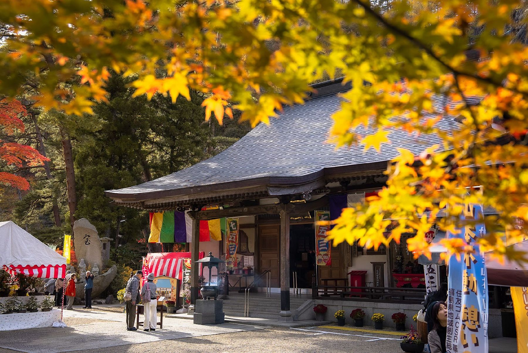
Yamamoto Fudoson Temple was built over 1000 years ago in a rocky cavern. The temple can be reached by taking paths lined with century-old Japanese cedar trees, and climbing a 130-step stone staircase. The cave that makes up part of the Yamamoto Fudoson temple grounds is where the Buddhist deity enshrined at this temple is worshipped. Yamamoto Fudoson Temple is located in Yamamoto Park. This park is centered in a valley – 5 km of which is designated as an Okukuji Prefectural Natural Park. A wonderful place for flower-viewing throughout the year, this area is also great for experiencing beautiful autumn leaves.
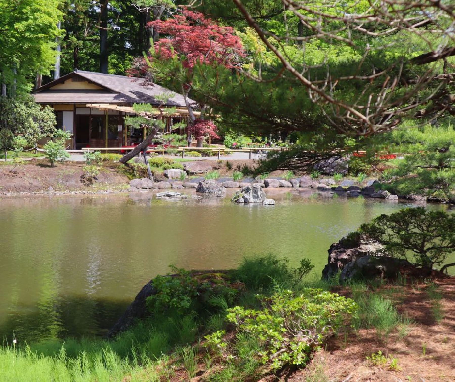
Jorakuen (浄楽園) is a traditional Japanese garden located in Fukushima City. It was completed by an expert gardener who worked on the famous Kinkaku-ji Temple in Kyoto, and it has a total area of about 25,000 square meters (over 269,000 square feet).The garden can be enjoyed in spring, summer and autumn. Spring brings about delicate cherry blossoms, irises, and rhododendrons; water lilies and lotus flowers adorn the ponds during the summer; and brightly colored trees decorate the park in autumn. No matter the season, the backdrop of the Azuma mountains makes for a spectacular sight at Jorakuen.There is a souvenir shop and traditional teahouse at the garden where visitors can enjoy matcha and Japanese sweets (‘wagashi’). The park remains closed during the winter season, from December 1st to March 31st.
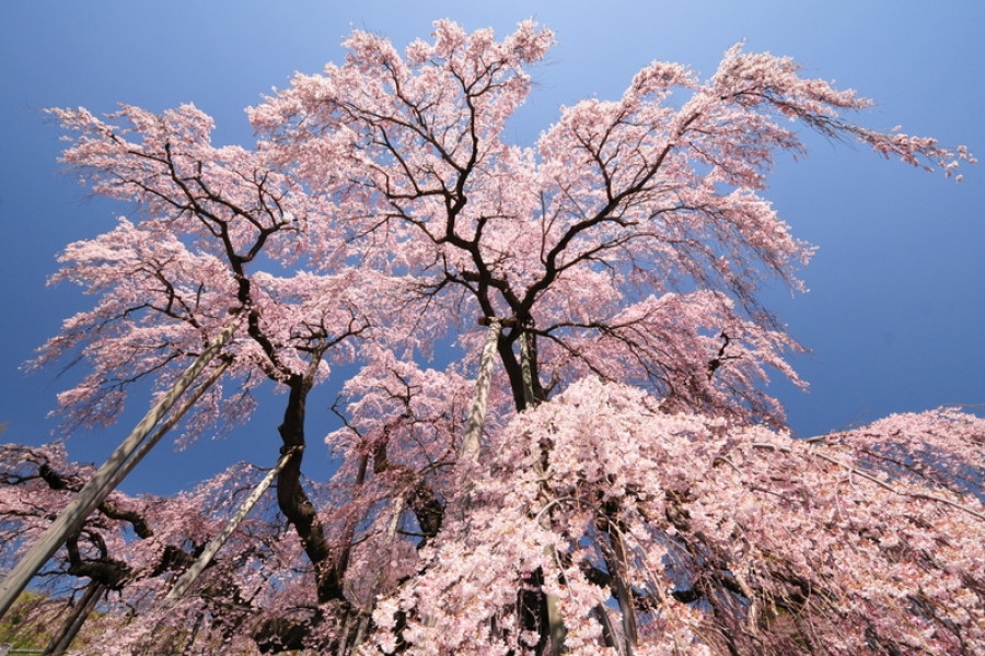
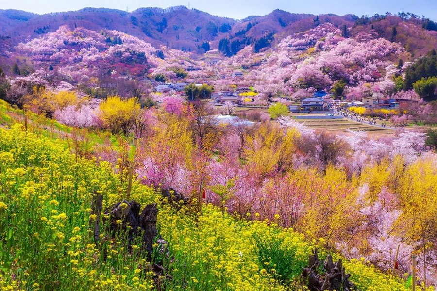
Miharu is a small town in central Fukushima Prefecture. The town’s name means “three springs” and it is easy to see how it got such a name. With cherry, plum, and peach trees blossoming in spectacular displays every spring, it is almost as if spring has tripled! But the most famous of the trees in Miharu is the Miharu Takizakura tree, which is a nationally recognized Natural Monument.Over ten centuries old, the beautiful Miharu Takizakura is a flowering cherry tree that spreads out in all directions and makes for a breathtaking vista. The cascading blankets of blossoms are how this tree got the name takizakura, or “waterfall cherry tree.” It is even one of the “three great cherry trees” of Japan (along with Usuzumizakura in Gifu and the Jindaizakura in Yamanashi Prefecture).Miharu Takizakura sits in a sakura hollow in order to protect it from the elements while providing excellent drainage. The heavy boughs of the tree are supported by wooden beams and lend to its elegant form. The Miharu Takizakura begins blooming from mid-April. During the day the sight is whimsical, but visit in the evening and you’ll be treated to an almost haunting beauty as the tree is illuminated.Aside from this huge cherry tree (over 12 meters tall and 18 to 22 meters in spread), the area is also blessed with various wildflowers, including cherry and rapeseed flowers. But, of course, the Miharu Takizakura is what the annual 200,000 visitors are there to see. The view from the base of the sakura is considered to be the most beautiful and the Miharu Takizakura often ranks as the best sakura tree in all of Japan.
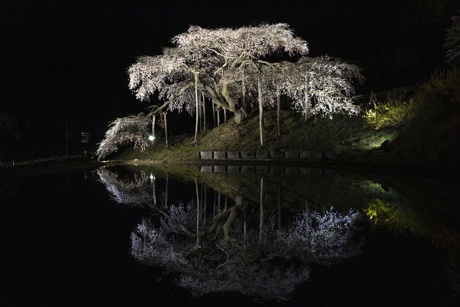
In spring, this 150-year-old weeping cherry tree looks so different from one hour to the next. Viewed during the day, it is framed against a backdrop of snow-topped Azuma mountains. During the cherry blossom viewing season, Nakajima Jizozakura is lit up at night, its reflection glittering enchantingly on the surface of surrounding rice paddies.
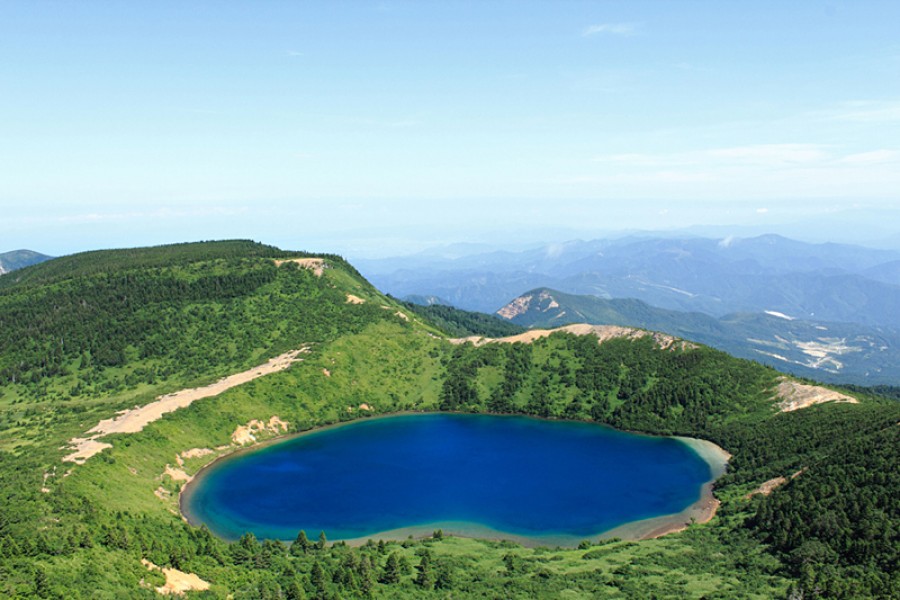
Majyo-no-hitomi, or The Witch's Eye Lake, is a volcanic lake that was formed during a volcanic eruption many years ago. Unique minerals in the water cause the lake to appear different colors, giving the lake its official name of Goshiki-numa (Five Colored Lake), but most often it is a bright blue. The nickname of “Witch's Eye” comes from the unique appearance of the lake that is visible in late spring when the snow melts enough so that only a white ring remains around the lake to form the white of what appears to be an enormous single eye.This lake viewpoint can be reached by an intermediate hike up Mt. Issaikyo that begins at the Jododaira Visitors Center, stop by for a map and safety information before hiking.